Saturday, December 12, 2009

Mount Arrowsmith - Lost Gully

With the amazing spell of clear and cold weather, conditions have been pretty prime for alpine climbing on the Island. I figured a "day-off" was in order to take advantage of the conditions.
Approaching the lower gully

Mount Arrowsmith has a host of great routes on it. The Lost Gully is a route I hadn't done yet. Supposedly it ranks up there in quality, and Phil Stone has even put it on his top 10 list for winter routes on the Island. Word on the street was that the road up Arrowsmith was still snow-free and driveable, so I thought I would have a look at the Lost Gully.

Looking out to Sproat Lake


There has been some recent logging on the flank of Arrowsmith, and I spent a little bit of time getting lost (eg followed the wrong trail-the one up "un-Judges"). After getting bluffed out once, I nearly packed in the trip, but was able to downclimb down a ways, and get over to the proper route into the Lost Gully.

Looking up the lower section of the gully. There wasn't continuous snow, so I got to get a bit of scrambling in crampons in.

Top of the lower gully and col with the south peak on Arrowsmith. Looking out across Georgia Straight.
The true "Lost Gully". More rock scrambling brought me into the classic upper gully.

Looking down Lost Gully to the col. Fun climbing.

Looking up Beaver Creek towards the Comox Glacier and Strathcona Park.

Along the traverse from the Lost Gully to the top of Arrowsmith.

Arrowsmith

Mount Cokeley

Traverse

I headed back down the standard Judge's Route. Definitely a fun climb. It was a little thin, but the snow was in perfect shape. Highly recommended.

Sunday, November 15, 2009

Fall Harvesting

We were a little slack on the garden this year, but did manage a small crop of yummies.

Me with the carrots. They were pretty tiny (these are the big ones!)


The tomotoes. We had a bumper crop this year, which was funny given we didn't plant any. We had oodles of them which came up as volunteers from spreading out our compost on the garden.


One of the few apples that actually grew on either of our 2 trees.

The "haul"

Chanterelles (I think) I found on a hike. Could not get a postive ID, so didn't risk eating them, despite the fact they looked quite yummy.

Kessa and the kids kept a garden at Gramp's farm in Cawston. They brought home a bunch of corn, tomotoes, peppers, onions.


Prepping some tomotoe sauce for canning.


We are still working our way through drying up boxes of apples.

Getting the Bees Ready for Winter

Time to get the mason bees in for the winter. The idea is to clean them up (and get rid of any mites) and put them in the fridge until spring.

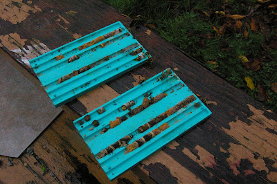
The inside of the nest box. The "mason" part comes from the work they do with dirt separating each cocoon. You can see the mites in the box and surrounding the cocoons.

Separating the cocoons from the box.

Wasps had invaded the box. There were about 8 or so that had made there way in. Didn't notice them until I pulled one of the trays apart. Luckily it is pretty cold out, so they were pretty groggy. The wasps get in and eat the cocoons.


We washed, soaked, cleaned and rinsed the cocoons.

Then we dried them off and put them in a box and into the fridge. Overall we started the season with 20 bees. There were about 50 in the nest, but a few were hit by the wasps as well as the mites. We ended up with a little over 40 for next year.

Monday, October 5, 2009

Steamboat and the Prow

I had planned a club trip to Steamboat Mountain for a while. After getting a glimpse of the peak last week, I was pretty pysched about the trip.

Steamboat Mountain is located near Ucluelet and Tofino and is one of the last mountains before you hit the open Pacific. The area has wonderful exposures of limestone with amazing karst formations. As a result, the area is pretty special amongst the caving community.

Of course the area isn't easy to get into. Despite a some-what secretive route/trail into the area, it is still a steep bushwack. As many folks on the trip jested, the area isn't likely to get popular any time soon.

On Saturday we bushwacked our way up to a lake below Steamboat. It took a little longer to get up there than we thought, so instead of heading up to the peak after we set up camp, we only were able to head up for a recci.

Looking up from camp to Steamboat Mountain (left) with the "Prow" on the right.

From the lake, we worked our way into a gully which had some amazing limestone exposures and karst features (grikes)


Looking up the gully

View from near the top


Looking along the ridge to the "Prow"

View out to Kennedy Lake and the Pacific

More limestone and the Clayoquot Plateau

Three of us decided to go have a look at the Prow. We had brought along a rope and gear, and glad we did. It was one of the more exciting leads I have done for a while.

We stopped for chinese food on the way home. As one of the trip's participants fortune cookie read "Your path to glory will be a rocky one, but rewarding".


Looking back to the notch from the top of the Prow

Rapping down the crux tower on the Prow

Saturday, September 26, 2009

Pogo Mountain

I've been wanting to get up Pogo Mountain for a while now. Pogo is pretty visible on the Highway out to Tofino. I organized a trip with the Alpine Club there earlier this year. On that trip it rained the whole time, and we got stuck trying to get around a bluffy section part of the way up which we couldn't make it around

Pogo from a trip I did to 50-40 Peak a couple of years ago

From the previous trip I had the access sussed out pretty well. With no snow this time, the part we got stuck on last time wasn't too bad.

Steamboat. I am heading up here next week


Upper section on Pogo. It was actually pretty fun scrambling. I stuck to the rock to avoid the bush.


On the way down, I tried to follow the actual "route" down. At one point I veered a little too far off to the side of the ride and ended up in some horrendous bushy cliffs. I was able to escape with only a minor flesh wound. The trip down took nearly 2 hours longer than going up!

Tuesday, September 22, 2009

Elkhorn Attempt


With a stellar forecast, and the family out of town, I decided that taking a day off for a ramble was in order. I have been keen on Elkhorn for awhile, and had an abortive attempt on it last year (though didn't make it too far).

Rumor is that Elkhorn is day-trippable. Given the shorter days at this time of year, I figured I would need an early start. Unfortunately I am not very good at getting up early in the morning. After a few hours of sleep, my alarm started crowing at 3:30 in the morning. I played the snooze game for 15 minutes, and after a bowl of granloa and yogurt, was off at 4:15. I pulled into Campbell River, zonked, at 6:00 and had to have a short nap before grabbing a coffee and taking off at 6:30.

I hit the trail at 7:45 (so much for an "early" start). I had the approach mostly sorted from my first trip into the area. Highlights included an au cheval log crossing over the Elk River, and a tarzan up a dodgy fixed rope up a wet, slimey cliff.

From the alpine, the mountain surroundings open up. You get some pretty good views around.

King's Peak

Looking along the ridge to Elkhorn. The route I tried heads up the big cleft to a notch on the right side of the mountain.

Rambler Peak

I followed the ridge up to the base of the mountain proper, where you have to swing around and try to get into a gully system on the west side of the mountain. Once in the gully, things got a little more challenging. The rock was a little wet, and the climbing a little funky. Being by myself I wasn't able to work up the courage to get past the first main obstacle in the gully, so turned around about 5 1/2 hourse into the trip. Still had a good hour or so to get to the top.

Base of routes on Elkhorn

Colonel Foster

Back down the ridge, down the slimy cliff, and over the river found me back at the car a little shy of 10 hours after starting. I was almost home before it got dark. Next time a rope and a partner are probably in order.